





Contents
Introduction
Era One, The Persian World: The First Global Imperial & Trade Empire, c. 550–330 BC
Era Two, The Birth of Islam, The Arab Expansion, & The Sunni–Shia Divide, AD 633 & Onward
Era Three, The Mongol Reset: The Largest Land Empire in History, AD 1206 & Onward
Era Four, Ottomans & Safavids: The Two-Empire Equilibrium, c. AD 1299–1914
Era Five, The Colonial Carve-Up & The Lines of 1918, c. AD 1800–1914 to the Modern Era
Where the Eras Converge into the Modern
Appendix I, Divide & Rule Applied: Four Case Studies
Appendix II, The Rising Powers
Appendix III, The Escalation Trap: Vietnam, Iraq, Afghanistan
Appendix IV, Water
Appendix V, Proliferation Risks to Asia: Pakistan, India, China, & Himalayan Water Sources
Appendix VI, The Hormuz Chokepoint, Commodities in Transit, & The World’s Strategic Petroleum Reserves in 2026
Introduction
For two and a half millennia, the lands stretching from the Mediterranean to the Pamirs and Tien Shan ranges, encompassing the Middle East and Central Asia, have been shaped and reshaped by a succession of empires. The common thread among them was their objectives of governing the territory, collecting revenue, and facilitating the movement of goods along its trade routes.
This region served as a vital corridor connecting four of the world’s earliest urban civilizations: Egypt, Mesopotamia, the Indus Valley, and China. Its strategic importance grew alongside the rise of Europe, Russia’s emergence as a major commodity producer, the expansion of African trade, and the spread of Indian influence into Southeast Asia. Together, these developments made it an increasingly critical point of connection. Whoever controlled the corridor wielded significant influence over global commerce, while the wealth it generated played a major role in the rise and fall of surrounding empires.
Our analysis is premised on the following assumptions:
- War is often driven by competition for water and energy. Food production combines both factors. Across much of the Middle East, water increasingly depends on energy for desalination. With current technological innovation, new commodities are now beginning to reshape a global system that, for over a century, had depended heavily on fossil fuels.
- Economics drives politics, and economic and political instability can lead to conflict. Civil conflict within a country is more common than wars between nations, and has a more negative effect on the economy.
- The key drivers of economic uncertainty we monitor are: (1) the Gini coefficient, (2) youth unemployment, (3) inflationary pressures, (4) national debt, and (5) large current account deficits, particularly those driven by food and energy imports. As these pressures intensify, political polarization tends to increase, more extreme leadership can gain support, and the risk of conflict rises.
- Large militaries can conquer smaller nations; however, occupying and governing them is far more difficult. The advantages and infrastructure that make a large military effective in an invasion can become liabilities during a prolonged occupation. Local forces often have greater motivation and a longer time horizon than the occupier, particularly when foreign troops have term limits on combat duty.
- Language is a fundamental source of identity. Religion can also become a powerful force during periods of economic or social insecurity, overcoming tribal and language affiliations.
- Understanding how a nation and its leaders may behave requires seeing the world as they see it and analyzing the motivations that shape their decisions. History may have limited influence on our worldview; however, it can be central to the identity of other nations, particularly when material needs are vulnerable or exposure to violence is high.
- Various nations in the region need oil at elevated prices (but within reason), not to destroy demand, and to balance their budgets.
We will examine the following major periods in the region’s evolution to better understand the forces that may shape future scenarios:
- The emergence of Persia as the world’s first major economic superpower following the era of the four ancient urban civilizations, and its first collapse with Alexander the Great’s invasion.
- The rise of the Arab civilization and the second collapse of Persia.
- The Mongol invasions and the third collapse of Persia.
- The post-Mongol era, defined by the dual power centers of the Ottoman and Persian worlds.
- The expansion of European colonial powers, the use of divide and conquer policies, the weakening of emerging market economies in the nineteenth century, and the post-World War I and II creation of the modern region and its enduring fault lines.
We draw the following conclusions:
- Iran currently holds an advantageous negotiating and geopolitical position because of two major developments this century. The invasion of Iraq brought a powerful neighboring state and substantial energy reserves into Iran’s sphere of influence due to a common religious affiliation. The current war has given Iran greater leverage over critical global commodities. Its influence may now be higher than at any point since its imperial era 2,500 years ago. Iran and its proxies may now be shifting from a retaliation strategy toward a more offensive posture, raising the risk that the conflict becomes broader and more violent heading into 2027. The generation now directing Iranian policy has been hardened by over two decades of war and is less united than the leadership it replaced. There is less of a centralized command and control to both wage war against and negotiate with.
- U.S. President Donald Trump needs a path toward de-escalation, as this war is among the most unpopular the U.S. has fought. Israeli Prime Minister Netanyahu has incentives to maintain pressure on Iran, as this war is popular in his nation. Both countries have pivotal elections in the fall of 2026. The air campaign also appears to have been less decisive than initially expected, which is consistent with the limited ability of air power alone to determine the outcome of conflicts. From Vietnam to Afghanistan, this has consistently been the case (Appendix III). As Iran emerges from the conflict with greater regional leverage, the allied coalition may face pressure to escalate further. A ground invasion would carry substantial risks. Iran has approximately twice the population of Iraq and 3.8 times its land area. Mountainous terrain along the coastal region makes an invasion far more difficult if the objective is to occupy the country or effect regime change. Access for ground troops from the North would cut them off from vital direct naval and air force support in the Arabian Peninsula and southern seas. The remaining options would include a broader campaign against energy and petrochemical infrastructure, occupation of critical islands in the Gulf, other more extreme military alternatives, as well as more onerous economic sanctions than what Iran has previously endured.
- Allies in the Middle East appear disappointed about the level of security they have been afforded during the conflict in 2026. As such, new alliances are rapidly reforming. Turkey is emerging as a potential beneficiary. At the same time, countries are also turning increasingly towards China. As Iran’s largest trading partner is China, it has some influence on resolving the hostilities.
- The proliferation risks of this conflict extend beyond the Middle East (Appendix V). Saudi Arabia and Turkey have strengthened ties with Pakistan, while India remains among the largest purchasers of Israeli weapons, and it is, in turn, a key supplier of critical defense commodities, including rare earth minerals. At the same time, tensions between India and Pakistan are elevated, with tribal revolts and insurgencies adding further instability in western Pakistan along the Iranian and Afghan borders. India has also demonstrated a willingness to use conventional military force, including an air-led attack in May 2025. China is a close ally of Pakistan, and all three countries have competing claims in Kashmir, a region that is also critical to their river systems and for water security. Both China and Pakistan have clashed with India there. All three nations have nuclear armaments. Additionally, despite the volatility along both its borders, Pakistan’s ties to Iran, Saudi Arabia, the U.S., and China have allowed it to play a leading role negotiating peace in 2026.
- Asymmetric versus conventional conflict vulnerabilities have been exposed as new technologies further evolve military tactics. If Afghanistan, throughout history, has remained a lower-GDP nation yet has been able to defeat the world’s major empires that came to occupy it through guerrilla tactics using its unique terrain, cheap drones are now proving to be just as instrumental in the modern age. Conventional militaries are showing bottlenecks in deploying expensive ordnance to counter an evolving battlefield. The supply of critical minerals is also becoming a strategic issue.
The pro forma scenarios we project as of the writing of this report are as follows:
- Iran retains influence on the straits, potentially in coordination with Oman. A certain amount of traffic through Hormuz resumes under a toll-based system. Various world leaders would likely support this outcome, given declining global petroleum reserves (Appendix VI) and the growing risk of a supply-shock-driven worldwide recession. Under this scenario, markets could remain relatively stable if oil prices remained contained.
- A large-scale attack and counterattack destroying significant energy and downstream infrastructure in the region. This would cause a substantial increase in the prices of oil and fossil-fuel derivatives. The resulting supply shock could trigger a worldwide stagflationary recession. Global equity and bond markets would inevitably decline. Certain sectors, however, such as hard assets and commodities, would be beneficiaries.
- A restoration of the free transit regime and access to Hormuz-related global commodities at the full capacity of pre-February 2026.
We apply the least probability to scenario 3.
Era One
The Persian World: The First Global Imperial & Trade Empire
c. 550–330 BC
Centuries before the Silk Road became known as a distinct trade network, a Persian-speaking world already extended across much of the Eurasian corridor. From the Scythians and Sarmatians on the western steppe to the Sakae in Central Asia and the Achaemenid Persians farther south, related peoples and languages spanned a vast region from the Danube to the Tarim Basin. Their cultural and linguistic ties helped traders, soldiers, and ideas move across thousands of kilometers. Few comparable networks had existed before, and few would emerge until the modern era with European global colonial expansion.
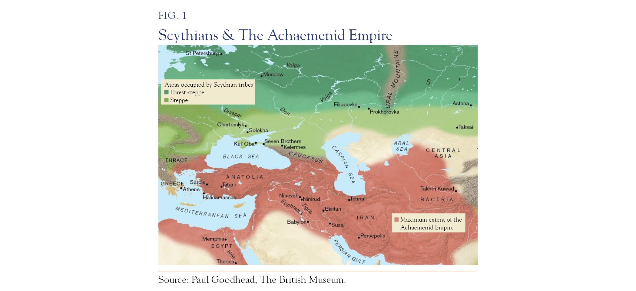
The Achaemenid Empire (c. 550–330 BC) was the pinnacle of this broader Persian world. As the first empire of genuinely transcontinental scale, it governed a very large share of the world’s population. Founded by Cyrus the Great and consolidated under Darius I, the empire stretched from Thrace and Egypt (Thebes) through Jerusalem, Babylon, Susa, and Persepolis to the Indus, joining the territories of three of the world’s primary hearths of urban civilization.
King Cyrus established a governing model based on conquest followed by accommodation. The cylinder bearing his proclamation to Babylon emphasized respect for local gods, the return of exiled peoples, and the restoration of temples. It is often popularly described as the first charter of human rights, an early recognition that an ethnically diverse empire could be governed more effectively through accommodation than through constant violence.
Darius I expanded the empire’s infrastructure and administrative reach. The Royal Road ran roughly 2,500 kilometers from Sardis, near the Aegean, to Susa, supported by a network of relay stations that allowed royal couriers to travel at remarkable speed. Herodotus described these couriers as stopped by “neither snow nor rain nor heat nor darkness of night.” The empire also introduced standardized gold coinage (the daric), completed a canal linking the Nile to the Red Sea, and governed through more than twenty satrapies that combined local autonomy with imperial inspectors. The Achaemenids did more than conquer existing trade routes. They created conditions that made long-distance trade reliable and routine.
Zoroastrianism, whose founder Zarathustra is now generally dated to the second millennium BC, rose to prominence under Achaemenid patronage. Its framework is best described as a dualistic form of monotheism. The concept of a supreme deity was unifying in nature, but the Achaemenid rulers did not impose it, and generally respected the religious practices of their subjects, including a wide range of polytheistic traditions.
When Alexander the Great brought down the Achaemenid dynasty in 330 BC, he did not replace the system; he inherited it, retained the satrapies, married into the Persian aristocracy, and was accused by his own generals of becoming a Persian king. His successors did much the same. The Seleucids preserved much of the Achaemenid administrative structure under Greek rule, while the Parthians and, later, the Sasanians restored it under Iranian rule and fought Rome along the same Mesopotamian frontier for seven hundred years. The Roman–Persian frontier of the third century AD resembles the Ottoman–Safavid frontier of the seventeenth century, marking the early emergence of a fault line that would continually reappear in the region.
Consequences: Persian became a language of administration, literature, and high culture across much of the region for centuries. It became a global lingua franca for traders in the corridor and its adjacent empires. The Achaemenid model of a tolerant, multi-ethnic, infrastructure-building empire also became an enduring template for later nations. Just as important, it helped shape Iran’s enduring self-conception as a regional civilizational center. That identity survived, in different forms, through the conquests of Alexander the Great, the Arabs, the Mongols, the Turks, and Russia and European colonial powers. Western commentary still often interprets modern Iran through the lens of this Persian imperial legacy. Yet the modern era is more fractured, contested, and complex than even the ancient.
Era Two
The Birth of Islam, The Arab Expansion, & The Sunni–Shia Divide
AD 633 & Onward
The second major transition came from the Arabian Peninsula and spread at a pace rarely matched in history, with the later Mongol conquests among the few comparable examples. By the time the Prophet Muhammad died in 632, he had unified much of the Arabian Peninsula. Islam drew on previous religious traditions deeply rooted across the Middle East, including Judaism and Christianity.
Within a decade of the Prophet’s death, his successors had taken Syria from Byzantium and broken the Sasanian field armies at Qadisiyya in 636. Egypt fell by 642, and the decisive defeat of the Sasanians came at Nahavand in the same year. Both regional powers had been weakened by a twenty-six-year war, the latest and most destructive phase of centuries of conflict between them. Their northern frontiers were also under pressure from repeated incursions by steppe peoples.
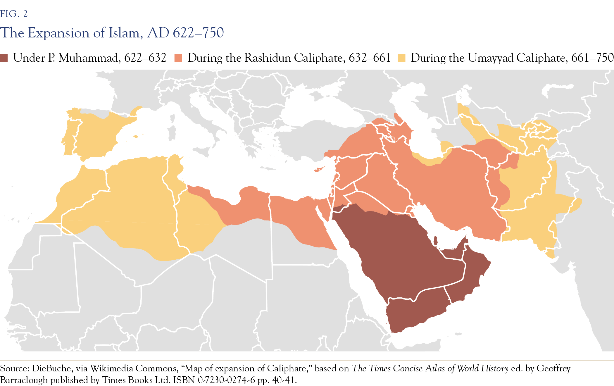
Within a century, Islamic rule had expanded in three broad stages. The first campaigns, from 622 to 632, were largely confined to the Arabian Peninsula and its northern marches. Under the first four caliphs, from 632 to 661, expansion reached the Levant, Egypt, Mesopotamia, and Persia. The Umayyad wave, from 661 to 750, extended the new order from al-Andalus (Spain) and the Maghrib in the west to Samarkand, Kabul, and Sind in the east (the Pakistan–India border), creating an empire that stretched from the Atlantic to the Indus.
Two developments from this period would continue to shape the region. First, the Arab conquests connected the southern and central trade corridors, linking the Mediterranean with the Indian Ocean and Egypt and Greater Africa with Persia and Transoxiana. For the first time since Alexander the Great, the Islamic world became a vast commercial and legal zone and a free-trade area supported by shared common contract practices; coinage standards (the dinar and dirham, direct descendants of the Byzantine and Sasanian coins they replaced); the suftaja, a credit instrument that let merchants move value across long distances without carrying coin, relying on networks of correspondent agents; and Arabic as a lingua franca. The caravan cities boomed. Baghdad, founded in 762 as a planned round city at the crossing point of the routes, is generally believed to have become the largest city in the world during the reign of C. Harun al-Rashid. Under the Abbasids, the corridor produced mathematics (al-Khwarizmi, whose Latinized name gave us “algorithm” and whose treatise title, al-jabr, gave us “algebra”), medicine, philosophy, legal innovation, advances in global navigation, and astronomy. Greek scientific and philosophical texts were translated into Arabic on a large scale, and Islamic scholars extended and transmitted them. Much of that corpus re-entered Latin Europe through the translation schools of Toledo and Sicily in the twelfth century, decisively shaping scholastic philosophy. Papermaking reached the Islamic world from China through Central Asia in the eighth century. Endowed colleges with substantial libraries were established across the Islamic world, forming a model later to be emulated by Western universities. The European “dark ages” were the Middle East’s “golden age.”
Second, and fatefully, the succession crisis after the Prophet’s death hardened into the Sunni–Shia divide. The dispute was political before it was theological. Who inherits authority: the community’s chosen elder, or the Prophet’s bloodline through C. Ali? The death of C. Ali (661) and the killing of his son I. Husayn at Karbala (680), both on Mesopotamian soil (Iraq), turned a constitutional argument into a permanent schism. Over the following centuries, the schism mapped itself onto the older fault line between the Arab world and the Persian world. Persia was conquered and largely converted and Arabized in script, but not in language or identity. Within two centuries, the Persians had captured the caliphate’s own administration from inside. The Abbasid revolution was launched from Khorasan in 747 and was victorious in 750; the vizierial families who ruled Baghdad were Persian. The eventual Persian embrace of Shi’ism as state religion (formalized under the Safavids) completed the transformation of a seventh-century succession dispute into a geopolitical boundary that persists today.
Consequences: Today, the Sunni–Shia fault line runs almost exactly where it did historically: through Iraq, along the Gulf littoral, and across the Levant, with Karbala and Najaf as its religious capitals. It stands as a demonstration that the corridor could be unified by faith and law rather than by dynasty alone, facilitating the fusion of trade routes with a common identity. Through this unity, Islam emerged as a global religion, the second-largest after Christianity. Furthermore, 80 percent of Muslims are of non-Arab heritage, amongst whom, in many cases, language remains an important association of identity and tribal affiliation.
Era Three
The Mongol Reset: The Largest Land Empire in History
AD 1206 & Onward
In 1206, at an assembly of steppe tribes on the Onon River, Temujin was proclaimed Genghis Khan, “universal ruler.” Within two generations the Mongols had assembled the largest contiguous land empire the world has ever seen: about 16 percent of the world’s land area, roughly 24 million square kilometers, at its greatest extent in the late thirteenth century, a single mass from Korea and the South China Sea to Hungary and the gates of Egypt, ruling perhaps a quarter of humanity with an army that never exceeded a few hundred thousand men. The map below does not show the territory of Emperor Babur, a Timurid prince descended from Genghis Khan, who founded the Mughal Empire in India in 1526 and whose dynasty was extinguished by the British in 1858.
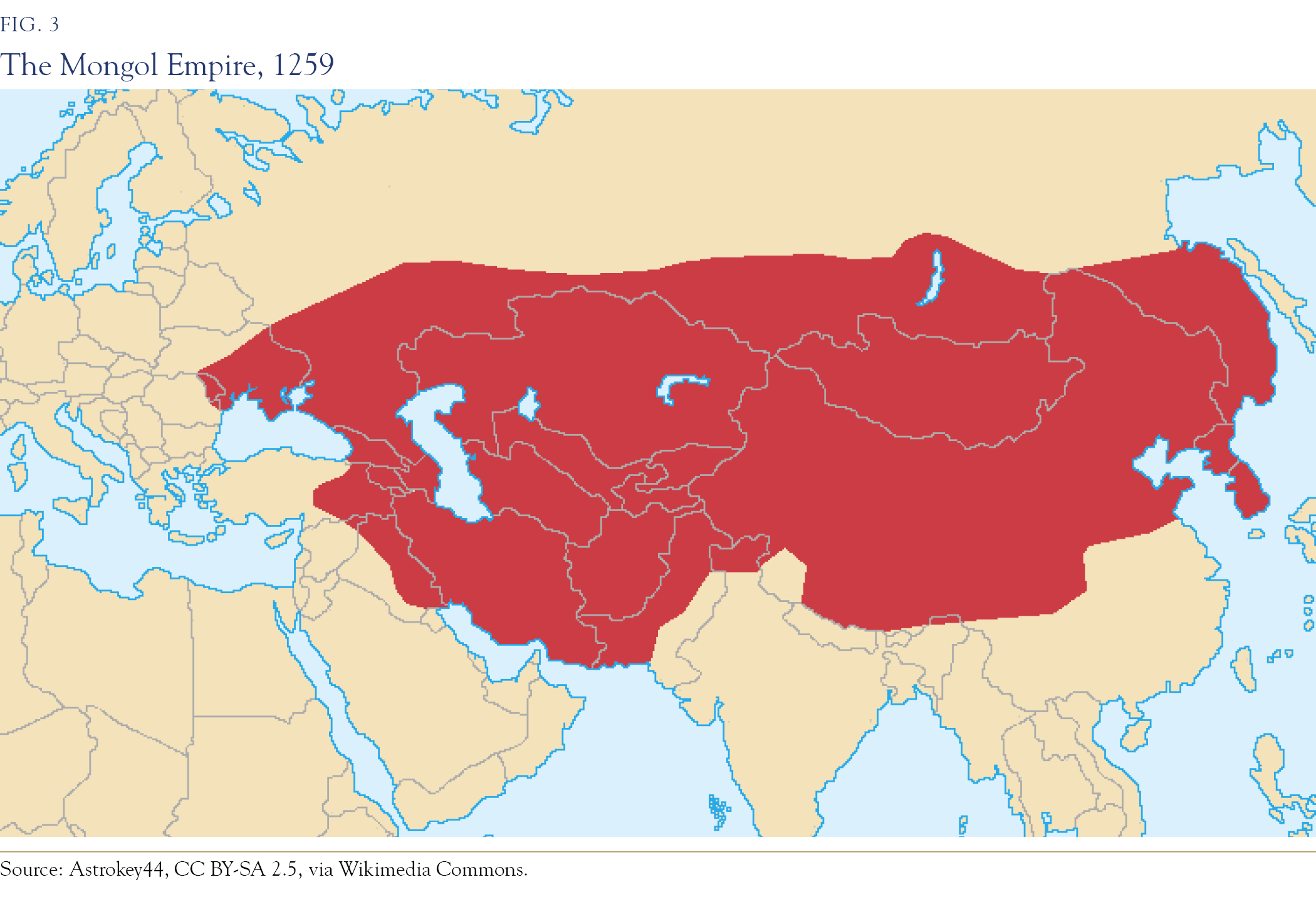
The Mongol invasions were devastating. Eventually, however, salient positive economic outcomes emerged.
On one side was destruction on a scale the region had never absorbed and in places never recovered from. The sack of Baghdad in 1258, with the caliph executed, ended the Abbasid caliphate and, with it, the classical Islamic world. The canal networks of lowland Mesopotamia, above all the Nahrawan system, and the qanats of the Iranian plateau and Khorasan depended on continuous maintenance and were extensively damaged. Some were never rebuilt, and Iraq’s agricultural population is often said not to have recovered its pre-Mongol level until the twentieth century. The great cities of the eastern Islamic world and the Rus, Merv, Nishapur, Urgench, and Kyiv, were reduced or erased. The center of gravity of the Islamic world was permanently displaced, westward to Mamluk Cairo and, later, Ottoman Istanbul, and eastward to India. The Arab Middle East, which had been the center of the world for six centuries, would not be sovereign again until the twentieth century, and the memory of that eclipse is part of the region’s political consciousness. The destruction fell most heavily on the Islamic heartland, the Khwarazmian lands of Iran and Central Asia, and, above all, Baghdad, seat of the Sunni Abbasid caliphate. The Mamluks rode out and defeated the Mongols at Ain Jalut in the Jezreel Valley in September 1260, breaking the myth of Mongol invincibility and sparing Egypt, its population, and its libraries from the destruction experienced further east. The Mongol devastation of centers of learning and depredations on the population resulted in an impairment of innovation coming from the region for several centuries.
Following these invasions, the economic evolution saw the emergence of the Pax Mongolica: the entire Silk Road fell under a single security umbrella. The Yam postal relay system moved urgent messages as far as 200 to 300 kilometers a day. The paiza, a tablet of gold, silver, or wood, functioned as a passport and requisition order across sixty degrees of longitude. Merchants paid one set of tolls instead of forty. The Mongols were among history’s most violent facilitators of trade, and among its most ecumenical: shamanists by origin, they ran an empire of Muslims, Buddhists, various Christian denominations, Jews, Zoroastrians, Pagans, Hindus, and Confucians, taxing all faiths equally and adopting, in the khanates, the religion of the majority that they governed. The Mongols’ eastern portion became effectively Chinese, and the center and south converted to Islam, integrating into the local populations and eventually adopting languages such as Persian and Arabic.
The same corridor that carried the silk carried disease: the Black Death traveled the Mongol trade network from Central Asia to Caffa to Genoa in the 1340s and killed over a third of Europe, a reminder that connectivity transmits more than just wealth.
The empire fractured within a century into four successor khanates, and the fracture lines became modern geography. The Golden Horde on the western steppe is the ancestral space of Russia’s empire. The Ilkhanate’s borders in Persia anticipate those of modern Iran. The Chagatai khanate underlies the Central Asian republics. The Yuan dynasty established a western reach into Tibet and Xinjiang. Muscovy rose as the Horde’s tax collector and then as its conqueror and framed its expansion south and east for the next four centuries as the reversal of Mongol rule, down the corridor, toward the warm water. This confirmed a shift of the center of Rus power, from Kyiv to the north-east and ultimately to Moscow, the echoes of which resonate today.
Consequences: A shattered Arab–Persian core and a displaced Islamic center of gravity. Russia’s centuries-long drive down the steppe corridor became an expansion justified in Russian memory as undoing the foreign rule. Here, where the borders of Russia, Iran, Central Asia, and western China meet, lies a crucial lesson. It is a demonstration, remembered by every land power since and studied explicitly by twentieth-century geopoliticians, that whoever controls the steppe corridor controls Eurasia.
Era Four
Ottomans & Safavids: The Two-Empire Equilibrium
c. AD 1299–1914
Out of the post-Mongol devastation, the region reorganized itself into a bipolar order that would last over five hundred years. On the western pole, a Turkish frontier principality in Anatolia grew, conquest by conquest, into the Ottoman Empire: Constantinople taken in 1453, the Arab lands and the holy cities absorbed in 1516–17, after which Sultan Selim I took the title Servant of the Two Holy Sanctuaries, and by 1683 the leading Sunni power at its furthest extent. It was the last empire to rule the corridor’s western half as a single space, and it did so with recognizably Achaemenid tools: religious pluralism institutionalized in the millet system, provincial autonomy under imperial inspectors, and control of the roads. The Turkic peoples from whom the Ottomans descended had converted to Sunni Islam.
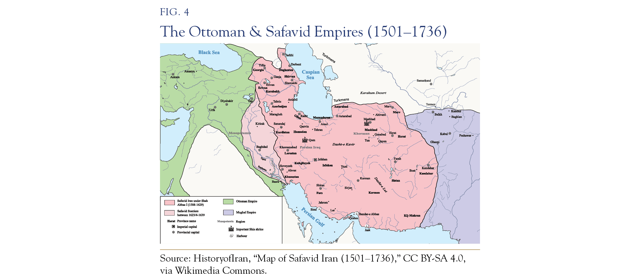
Facing it to the east stood a re-established Persia. In 1501, the Safavid dynasty took Tabriz and made Shi’ism the state religion of Iran. Shah Abbas rebuilt Isfahan into one of the world’s great cities, ran silk exports to Europe around the Ottomans via Armenian merchant networks, and made Iran a confessional state whose church-state unification runs in a line to the Islamic Republic. This is the moment the modern map was drawn.
The Ottoman–Safavid wars of the sixteenth and seventeenth centuries were fought across Mesopotamia and the Caucasus, over Baghdad, over the Shia shrine cities, over the caravan routes, and the Treaty of Zuhab (1639) fixed a border between the two empires that is, to a first approximation, the Iran–Iraq and Iran–Turkey border today. Sunni Istanbul versus Shia Isfahan, the Arab lands as the contested middle, the Gulf as the seam, each side sponsoring co-religious populations in the other’s territory. The echoes of such political affiliations are the basis of modern proxies.
Meanwhile, the world was routing around both powers. Vasco da Gama rounded the Cape of Good Hope in November 1497 and reached Calicut in May 1498, seeking a sea route that would bypass the Mamluk and Venetian intermediaries who then controlled the Red Sea and Alexandria trade. The long diversion of Eurasian commerce from land to sea had begun. Overland trade thrived well into the seventeenth century; however, the compounding logic was merciless: sea freight was cheaper per ton-mile, scaled better, and enriched the Atlantic states that would eventually come back around to carve up the land corridor itself. The empires that controlled the Silk Road slowly became the ones the trade bypassed. They remained formidable; however, they were increasingly technologically outpaced by the nineteenth century.
Consequences: The Sunni–Shia rivalry was institutionalized as a state rivalry between an Anatolian–Arab pole and a Persian–Arab pole, complete with proxies across the region. The 1639 border is still on the map, reflecting the deep fusion of the Iranian state with clerical authority. It leaves behind a fatal lesson: control of overland routes diminishes power once sea lanes emerge, followed later by pipelines, the straits, and eventually air routes. Today, as global oil demand peaks, these power dynamics will shift, and countries whose economies are dependent on petroleum exports will face headwinds.
Era Five
The Colonial Carve-Up & The Lines of 1918
c. AD 1800–1914 to the Modern Era
Before WWI, European expansion against the Ottoman Empire was persistent—French Algeria (1830) and Tunisia (1881), Italian Libya (1911), Spanish Morocco (1912), British Egypt (1882) and the Suez Canal that made Egypt worth having, the Anglo–Egyptian Sudan (1899), Aden (1839), Kuwait (1899), the Trucial Coast (1820, with the protected-state relationship established by the Exclusive Agreements of 1892)—the entire sea route to India secured. The Anglo–Russian Convention of 1907 divided Persia into a large Russian sphere in the north, a smaller British sphere in the south-east screening the approaches to India, and an unallocated neutral zone between them. Persia was not a party to the agreement. The Ottoman Empire had been reduced. In 1908, oil was struck at Masjed Soleyman in Persia. The Anglo–Persian Oil Company was floated in 1909. From 1912, the Admiralty under Mr. Churchill committed the fleet’s newest capital ships to oil, with the British government buying a 51 percent stake in the company in June 1914 to secure supply. The corridor, bypassed by the age of sail, was about to become the fuel tank of the world.
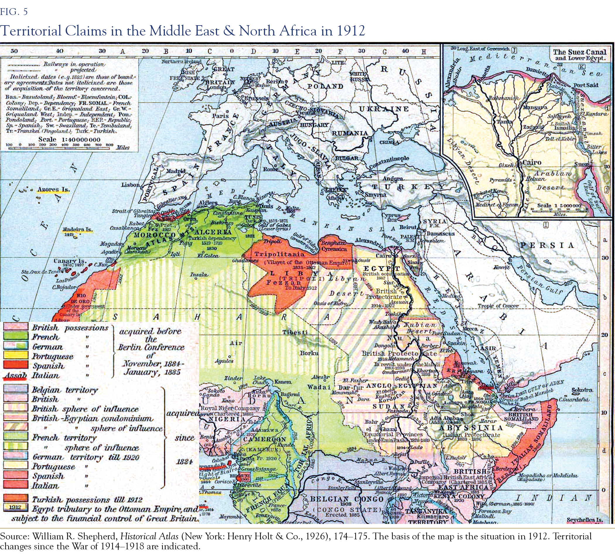
In WWI, the Ottoman Empire was allied with the side that was to be defeated. Between 1916 and 1923, the victors did what no previous imperial powers had done: they replaced the region’s organic political geography, empires, tribal confederations, millets, pilgrimage and caravan networks, with lines. The Sykes–Picot agreement (1916) divided the Ottoman Arab lands into British and French spheres while the war was still being fought. Britain was simultaneously promising much of the same territory to the Sharif of Mecca in exchange for the Arab Revolt, and a national home in the Levant to the Zionist movement in the Balfour Declaration (1917), incompatible promises over one territory, which remain a foundation of the present dispute. The San Remo Conference (1920) converted the spheres into mandates under the League of Nations. The borders of Iraq, Syria, Lebanon, and Transjordan were drawn to suit colonial rule. Mosul was moved from the French to the British sphere largely for its oil prospects. Lebanon was carved from Syria to give France a Christian-majority client. In Iraq, a Sunni minority monarchy was installed over a Shia majority, an inversion that would take until 2003 to unwind, at an enormous cost. The Treaty of Sèvres (1920) provided for local autonomy in the Kurdish areas east of the Euphrates and a conditional route to independence, subject to a League of Nations finding. Sèvres was never ratified, and the Treaty of Lausanne (1923) that replaced it made no provision for the Kurds who were distributed across four countries.
Subsequently, Europe engaged in the world’s largest known conflict. The Second World War is best understood as a continuation of the First. The two wars together bankrupted the colonial powers and ended European superiority, India was gone in 1947, the attempt to retake Suez failed in 1956, and Algeria was lost in 1962 after an eight-year war of exceptional brutality. Britain’s withdrawal from East of Suez was completed by 1971. At that point, the United States inherited the chokepoints, the Gulf commitments, and the contradictions, and the Soviet Union inherited Russia’s drive down the land corridor, ever seeking warm-water access. Europe eventually withdrew, ending a system of colonial extraction whose economic costs to the governed territories were among the most exploitive in history. The lines, however, remained. The states of the modern Middle East are, to a substantial degree, the output of the 1918 settlement. The guns of the Somme never went silent, and in the modern era, were replaced by the hum of drones.
Consequences: Today’s conflicts directly reflect these historical fault lines. The wars in and around Iraq and Syria are battles over the viability of the Sykes–Picot borders, just as the Israeli–Palestinian conflict flows directly from the Balfour Declaration and the British Mandate. Meanwhile, the Saudi–Iranian rivalry manifests as a Sunni–Shia bipolarity, operating with new capitals but along the same historic seam.
Where the Eras Converge into the Modern
The maps in this section tie together the legacies of these previous eras. The religious map of the region today displays the modern distribution of Sunni and Shia populations, highlighting a clear historical continuity. Today’s “Shia crescent”—which spans Iran, southern Iraq, the Alawite littoral of Syria, Hezbollah-controlled Lebanon, the Zaydi highlands of Yemen, and the Shia-majority districts of the Gulf—closely approximates the old Safavid sphere and its clients. Conversely, the surrounding Sunni belt mirrors the core domains of the former Ottoman territories. The religious distribution echoes the last two dominant empires. Neither empire has existed for a century—the Safavids far longer—yet their former borders are the single best predictor of alignment in the conflicts the region has fought since 1979.
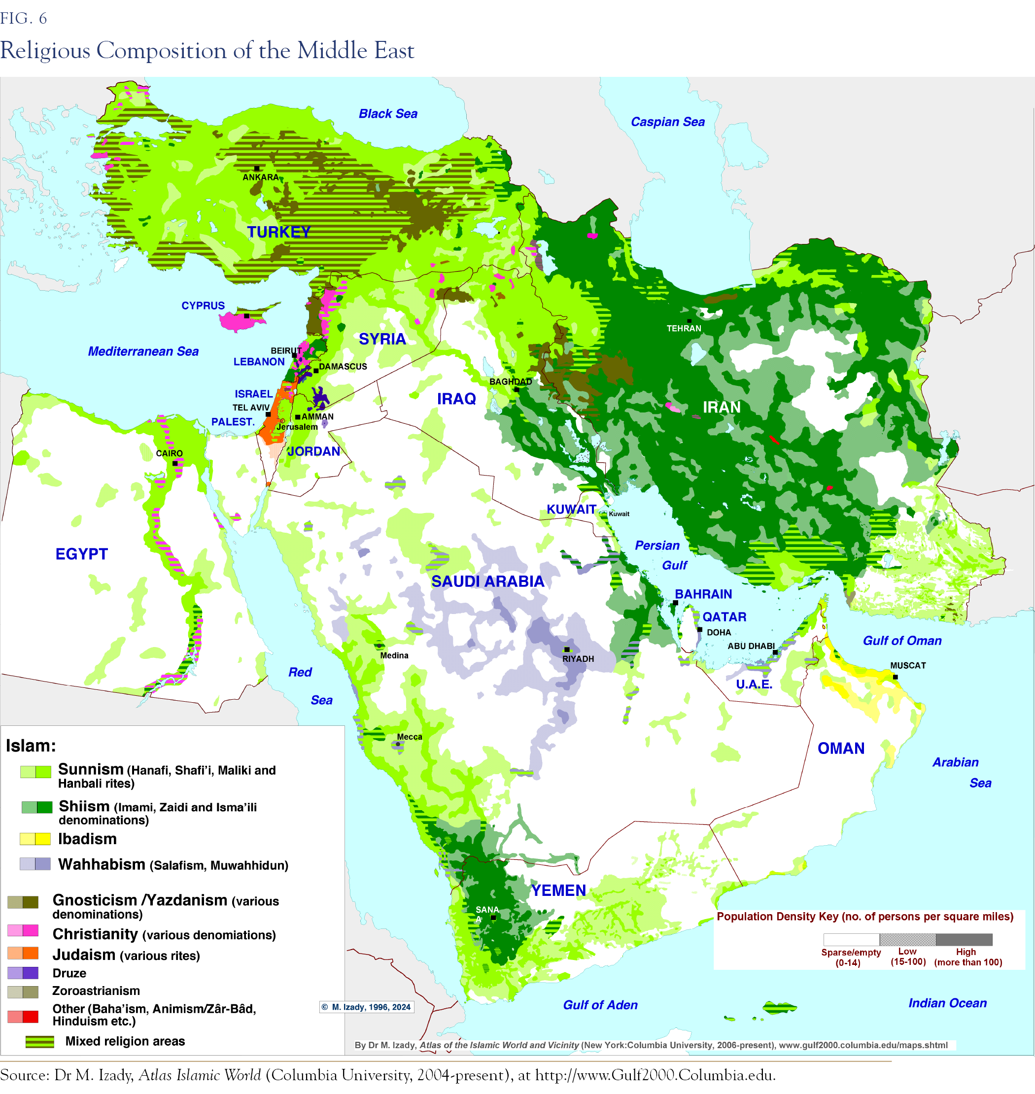
An economic dimension gives the rivalry its material stakes: the religious map and the hydrocarbon reserves overlap—the dark-green Shia band on the map below runs through southern Iraq, Iran, and the Gulf littoral, including the Saudi Eastern Province, and contains the largest share of the world’s conventional oil. The 2003 invasion of Iraq did not merely flip a government; it moved massive reserves into the Iranian sphere of influence. The Saudi–Iranian confrontation, the region’s key long-term conflict, has been conducted on the basis of petro-economic calculations.
As important as religion is, our premise is that language is key to identities. Within the region, this is especially strong outside the Arab world.
Due to various earlier-era invasions and migrations, Turkic and Semitic language speakers, as well as large Indo–European tribes, including the Kurds and the Baloch, make up significant parts of the Iranian population. It is more diverse now than it was 2,500 years ago.
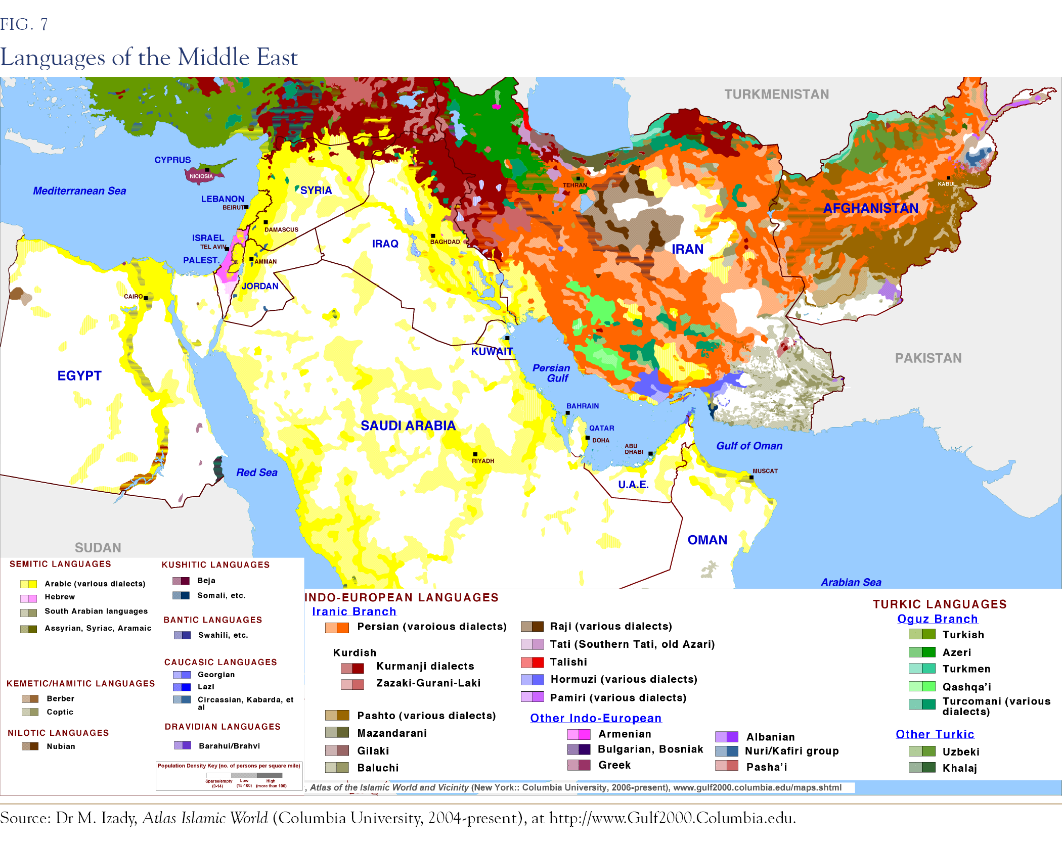
Afghanistan is a buffer zone with large Pashto-, Balochi-, Dari-, Uzbek-, Turkoman-, and Farsi-speaking populations outside its borders. Despite its ethnolinguistic diversity, its topography, shaped by the convergence of three massive geological plates and marked by two strategic passes serving as transit points, makes it a natural fortress at the crossroads of overland routes to the Indian Subcontinent.
Great Britain and France drew the modern borders of the region between 1916 and 1948. Imperial cartographers did not merely ignore religious-linguistic maps; in crucial cases, they cut across them. “Divide and rule” allowed European empires to govern hundreds of millions with tens of thousands, a method perfected in India and applied to other colonies. The policy was to install a minority over a majority, ensuring the minority’s survival depended entirely on the imperial guarantor. This mechanism was evident in the placement of a Sunni Hashemite king over Shia-majority Iraq, as well as the recruitment of Alawites, Druze, and other minorities into France’s Troupes Spéciales in Syria, which became the pathway by which the Alawite Assads eventually captured the state. Maronite primacy was likewise hardwired into Lebanon’s constitution on the strength of a single colonial-era census taken in 1932 and never repeated, while the Kurds were apportioned across four states. Every one of these arrangements outlived its architect, and each ultimately ended in violence: Iraq in 2003, Syria in 2011, Lebanon chronically, and the persistent Israeli–Palestinian conflicts.
Appendix I
Divide & Rule Applied: Four Case Studies
This was the operating system of European colonial empires, and its four most consequential applications bracket the region on every side. The model was as follows: institutionalize a communal division for administrative expediency, balance the communities against each other so that neither could challenge the imperial center, and then, when the cost of empire exceeded its return, withdraw quickly, leaving the division behind as the successor states’ founding condition. The empire’s exits were as consequential as its rule, laying the basis for conflict in the modern age. Even when not present, the empires’ influence would remain.
Case 1: Israel–Palestine is the purest case of incompatible promises maturing simultaneously. The Balfour Declaration promised a national home for the Jewish people in a territory that was simultaneously covered by the McMahon correspondence with the Sharif of Mecca and by the Sykes–Picot allocation to international administration; three claims, one former Ottoman province. For 30 years of mandate rule, Britain balanced European immigration against Arab revolt, arming and suppressing each side by turns, until the balancing became untenable. In 1947, it handed the problem to the newly established United Nations, announced a departure date, and left in May 1948 without any transfer of authority. The war began the day the last High Commissioner left, and in a real sense has never ended.
Case 2: Lebanon shows the mechanism in its French variant, with similar consequences. The confessional state built around the 1932 census—six Christians to five Muslims in parliament, a Maronite presidency, a Sunni premiership, a Shia speakership—froze a demographic moment into a constitution. The census was never repeated because the arrangement could not survive an updated count. The Shia, the fastest-growing community, were locked into the junior share. Subsequent Lebanese crises, (1958, the 1975–90 civil war, and the paralysis of the present) are a renegotiation of that frozen ratio, conducted with outside sponsors because the constitution guarantees that no community can win inside the rules.
Case 3: Kuwait is the case where the line was drawn, literally, in an afternoon. At Uqair in December 1922, Sir Percy Cox settled the borders between Iraq, Nejd, and Kuwait. According to an eyewitness account, he took a red pencil to the map when the delegates were deadlocked. The settlement capped both neighbors: Iraq was left with 58 kilometers of shoreline and limited access to deep-water ports. The 1899 protectorate had originally detached Kuwait from Ottoman Basra to keep the Berlin–Baghdad railway from reaching the Gulf.
Case 4: India–Pakistan is the largest proliferation risk of the current Mideast conflict. Separate communal electorates, introduced in 1909 and expanded thereafter, made religion the organizing category of Indian politics two generations before independence. A Muslim politician’s constituency was Muslim by law, and the incentive structure followed. When exhaustion forced the exit, it was catastrophic in its speed: Viceroy Lord Mountbatten advanced the transfer of power by ten months, and the boundary between the two new states was drawn in roughly five weeks by Cyril Radcliffe, a barrister who had never previously set foot in India, working from out-of-date maps and census tables, with the award published two days after independence itself, so that on the day of freedom, tens of millions did not know which country they lived in. Partition killed up to over one million people, displaced on the order of possibly fifteen million, and left Kashmir, a Muslim-majority princely state, with a Hindu ruler, precisely the ambiguity the system generated, as a permanent war. Both nuclear-armed countries have fought several conventional wars and remain in a tit-for-tat asymmetric conflict.
Consequences: Four partitions, four standing conflicts: Israel–Palestine, Lebanon’s frozen constitution, Iraq–Kuwait, India–Pakistan. In each case, the communal division was institutionalized by colonial power, and the exit was rapid enough to turn the administrative division into war. The 1918 to 1948 lines are not just historical background but are active ordnance for current conflicts.
Appendix II
The Rising Powers
The two states now assertively projecting power across the corridor are the former regional powers: Turkey and Iran. The southern Arabian oil-resource-rich states have also attempted to exert regional control, countering the two historic regional poles.
Iran’s reconstitution came first and is the more explicit. The 1979 revolution fused the Safavid inheritance, a Shia state with clerical authority wired into sovereignty, with modern revolutionary method and then spent four decades building what the Safavids never achieved: an integrated forward presence across the seam, through allied movements and clients in Iraq, Syria, Lebanon, Yemen, and the Gulf’s Shia communities. The “axis of resistance” is the Safavid sphere reassembled by other means.
Turkey’s reconstitution came later and more quietly. Its instruments are modern: a cutting-edge drone industry that has reshaped battlefields from Syria and Libya to the Caucasus and Ukraine. Ankara has established vital military footholds in northern Syria, northern Iraq, Qatar, and the Horn of Africa, while simultaneously building patronage networks across the Sunni political spectrum and exercising leverage over the Turkish Straits, the corridor’s oldest chokepoint. Where Iran assembled a cohesive Shia axis, Turkey has bid for leadership of the Sunni world.
The result is that the map of active friction in the 2020s reproduces the Ottoman–Safavid frontier. We see this in northern Syria and northern Iraq, where Turkish forces and Iranian-aligned forces operate in adjacent and sometimes overlapping zones. It appears in the Caucasus, where Turkish-backed Azerbaijan’s victories in 2020 and 2023 overturned the equilibrium Iran preferred on its own border, with Lebanon and the Gulf serving as the maritime flanks. Both of these rising powers are non-Arab, and both are contesting primacy over an Arab center. Consequently, both channel this contest into competing claims for religious leadership, echoing the mantles of their imperial predecessors.
Appendix III
The Escalation Trap: Vietnam, Iraq, Afghanistan
The escalation trap has plagued superpowers attempting to reenter the former colonial spheres. An external power enters a local conflict with limited aims and superior technology. The local adversary, fighting at home, converts the contest from one of firepower to one of endurance; each increment of external commitment fails to be decisive but raises the cost of leaving, because withdrawal now forfeits not just the original objective but the credibility staked on every previous increment and on future engagements. The intervention is thus sustained long after its expected value has turned negative, ending in an exit on worse terms than were available years earlier. The trap is not a failure of intelligence. Every power that entered one believed, with reason, that it was stronger, and it was. Strength was never the deciding variable; the asymmetry of stakes was. The local side is fighting for its existence and therefore cannot leave. The external side is fighting for an interest and therefore, eventually, does. Democratic election cycles also impede the tactics necessary for the occupier to maintain its strategic objectives.
Vietnam set the template. The commitment ratcheted from advisers to an air campaign, to more than half a million ground troops by 1968, through a sequence of individually reasonable decisions, each justified by the credibility invested in the last. The adversary absorbed an excessive bombing tonnage, and negotiated anyway, from the only position that mattered: it would still be there when the external power was not. The substance of the 1973 terms had been available five years earlier, before half the war’s casualties. Two years after the exit, the client state fell.
Iraq (2003–11, with the forced return of 2014) added the demonstration that decisive conventional victory does not exempt the victor but delivers the same trap. The war of maneuver lasted under one month. The subsequent occupation lasted nearly nine years, against an insurgency and in a society whose mandate-era fault lines, (the Sunni-minority state built in 1921 and inverted in 2003), the occupation reopened. The mission migrated as the trap deepened: disarmament, then regime change, then nation-building, then merely “stability.” The 2007–08 surge led to an orderly exit rather than the original objective. Within three years of the 2011 withdrawal, the client army collapsed, and the war returned with the rise of the Islamic State, requiring re-entry in 2014. The corridor’s oldest asymmetry applied throughout: the occupier’s timetable was electoral; the insurgents were generational.
Afghanistan (2001–21), the longest war in American history, ended in the restoration of the government it began by removing. The conflict had a similar pattern as to previous ones: a swift initial victory, migration of aims from counterterrorism to state-building, the sanctuary across a border no amount of force could close, a client state whose dependence was the intervention’s own product, and which dissolved in eleven days once the guarantor’s departure date was fixed. The war was waged by four successive administrations, each of which privately concluded it could not be won and publicly escalated or extended it rather than absorb the cost of ending it on their own watch. The exit was a cycle back to the entrance.
Appendix IV
Water
The first assumption of our analysis—that war is driven by water and energy, that food is the combination of the two, and that in much of the Middle East water is in fact energy—is not a modern premise. This is the region’s original condition. Before the five eras, beneath the religious and linguistic makeup, there is the first driver: water. The Fertile Crescent is where the region’s conflicts have occurred. Without water, there is no life, nor civilization.
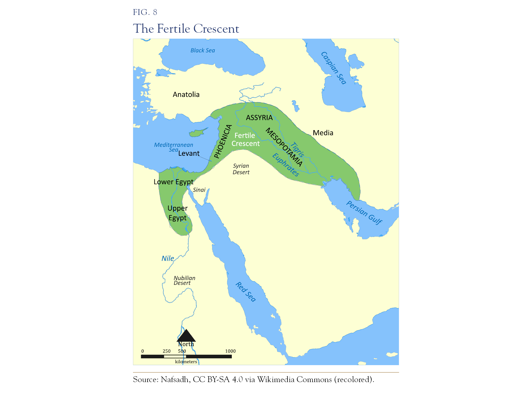
The same map explains the corridor’s strategic geometry, revealing why the trade of the four original urban civilizations, and later of three continents, funneled through this ground. The crescent is the watered land bridge connecting Africa, Europe, and Asia; anyone traveling from Egypt and the Mediterranean to Mesopotamia, Persia, India, and China has no alternative but to follow the green, or else take to the sea. Yet, this green expanse is interrupted by two strategic gaps: the Syrian Desert lies between Damascus and the Euphrates, and the Sinai lies between Gaza and the Nile. Anyone traversing the region over the past five thousand years has had to stage at the last major watered grounds before those crossings, which is why these transit hubs became the ever-contested real estate of the region. Palmyra grew rich as the waterhole in the middle of the Syrian gap, just as Damascus and Aleppo flourished as staging cities on its edge, and Gaza stood as the gate of the Sinai Road. This narrow Levantine strip between the sea and the desert—the land bridge’s land bridge—became fiercely contested throughout history because whoever moved between the two great river civilizations, Egypt on one side and Mesopotamia on the other, had to pass through it. Hydrology has been the key driver of power and control in the Fertile Crescent for millennia, since humans began to practice agriculture and establish urban civilizations in this critical region.
Turkey’s dam network on the Tigris and Euphrates controls water into Syria and Iraq. Similarly, the Nile is now contested between Egypt and upstream Ethiopia’s Grand Renaissance Dam. Across every change of government for a decade, Cairo has repeatedly stated that control of the river is existential. Finally, the Jordan basin fed directly into the modern wars. The 1964–67 struggle over the river’s headwaters, pitting Israel’s National Water Carrier against the Arab diversion projects, was among the key escalations that produced the Six-Day War. Geopolitically, the Golan Heights are, in hydrological terms, the high ground of a watershed that still supplies a third of Israel’s fresh water.
In the Middle East, water and energy have fused into a single element. Desalination supplies the great majority of the Gulf’s municipal water.
Appendix V
Proliferation Risks to Asia: Pakistan, India, China, & Himalayan Water Sources
Pakistan has formally aligned with Saudi Arabia. On September 17, 2025, days after the Israeli strike on Doha, Riyadh and Islamabad signed the Strategic Mutual Defence Agreement, committing each to treat an attack on one as an attack on both. Pakistan is a nuclear-armed state outside the Nonproliferation Treaty, and the pact effectively extends its deterrence to Saudi Arabia—an outsourced nuclear umbrella.
India, meanwhile, has aligned with Israel. This partnership has grown in two decades from discreet arms purchases into a deep defense-technology relationship: air-defense systems co-developed, armed drones, loitering munitions, electronic warfare, and an intelligence relationship both sides treat as strategic. The symmetry with the western theater is imperfect in an important way: India simultaneously maintains its Chabahar port project in Iran and buys Russian systems, hedging as a would-be pole rather than enlisting as a client. Riyadh–Ankara–Islamabad on one side of the seam, Jerusalem–New Delhi in structural sympathy on the other, with Tehran hostile to both Pakistan (the Baloch frontier, the January 2024 exchange of strikes) and the Saudi bloc.
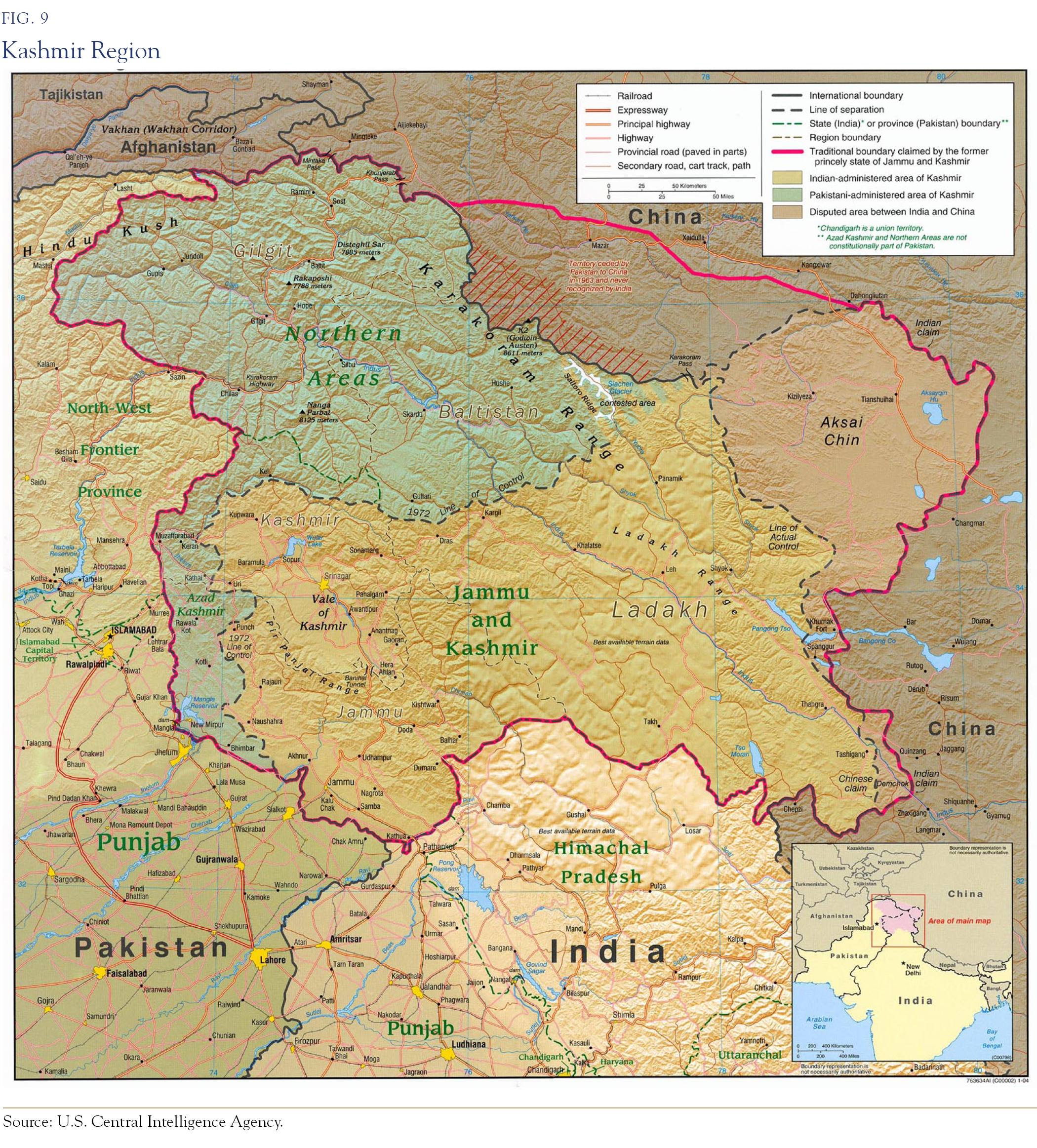
Two features of the 2025 four-day war between India and Pakistan matter for the forward scenarios. The first is technological. The air battle was the first large-scale combat meeting between current-generation Chinese and Western systems, (Pakistani J-10C fighters firing PL-15 missiles against Indian Rafales) and Pakistan claimed multiple kills, with independent and French acknowledgments confirming at least one Rafale lost. The details remain contested. Chinese air combat systems performed at or near peer level against premier European equipment, at a fraction of the price, watched in real time by every air force and procurement ministry in the emerging markets.
The second feature is hydrological, and it is the more dangerous precedent. In the immediate aftermath of Pahalgam, India placed the Indus Waters Treaty in abeyance, suspending, for the first time since 1960, the World Bank-brokered agreement that had survived three full wars untouched, and that governs the river system on which Pakistan’s agriculture and most of its population depend. Pakistan declared that any attempt to divert or withhold its waters would be treated as an act of war and has since warned that water coercion carries consequences for regional peace.
The Baloch insurgency, a tribal war spanning the Iran–Pakistan–Afghan border, has entered its most lethal phase in decades. Chinese-built infrastructure and connections to the Arabian Sea port are primary targets, along with Pakistani military units and civilians. Further north, the Taliban, effectively a Pashtun confederacy, cross the Durand Line with virtual impunity. This contested region, which the British Empire attempted to subjugate three times (four, if we include the modern war), is falling back into the throes of active hostilities. Foreign sponsorship of tribal elements accelerates these asymmetric conflicts.
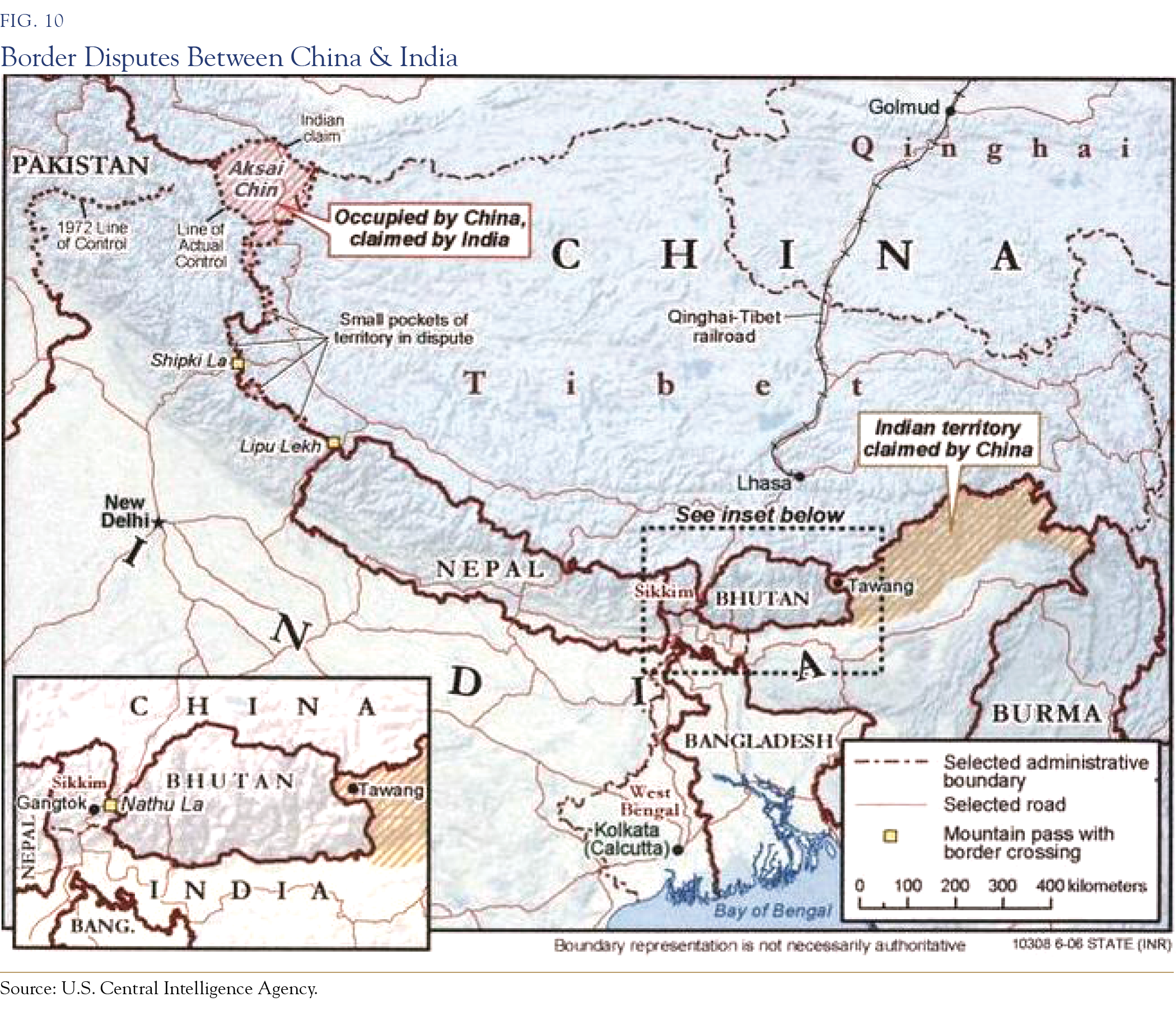
On the eastern flank rises the Hindu Kush–Karakoram–Himalaya system, often called the “Third Pole.” Holding more frozen water than anywhere outside the polar ice sheets, this system is the source of the Indus, the Ganges, and the Brahmaputra. Upon these rivers, India, Pakistan, Bangladesh, and through the Brahmaputra’s upper course, China, together stake close to two billion lives. The Indus system alone dictates Pakistan’s very existence, as the vast majority of its agriculture and population are concentrated within the Indus basin, which is fed disproportionately by glacier melt and snowmelt. Crucially, these life-giving mountains lie, in large part, within disputed Kashmir. Kashmir is a valley and a population. It is also a vital water tower.
Appendix VI
The Hormuz Chokepoint, Commodities in Transit, & The World’s Strategic Petroleum Reserves in 2026
Commodities
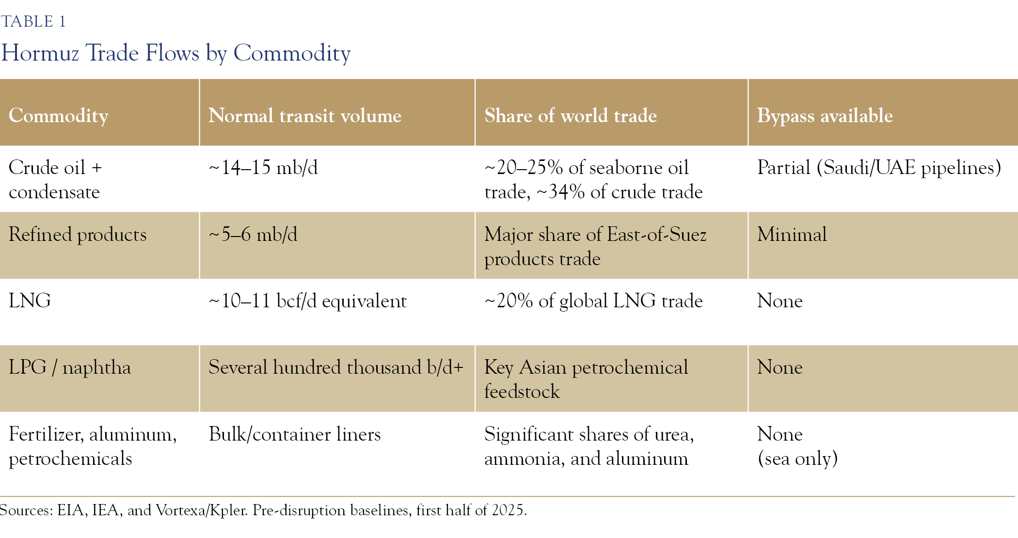
Crude oil and condensate form the bulk of the flow: the exports of Saudi Arabia, Iraq, the UAE, Kuwait, Iran, Qatar, and Bahrain. Refined products add several million barrels per day from the Gulf’s expanding refinery complexes. LNG is the Strait’s second strategic cargo. Qatar ships over 110 billion cubic meters a year, with more than 90 percent passing through Hormuz, and 96 percent of the UAE’s LNG exports transit it, together roughly a fifth of global LNG trade, for which no bypass exists. LPG and naphtha flows make the Gulf the feedstock reservoir of Asia’s petrochemical industry, so a Hormuz interruption spreads within weeks into polymers, plastics, and fertilizer. The non-energy cargo also matters. The Gulf states are among the world’s largest exporters of nitrogen fertilizers (natural gas transformed: food as water plus energy in tradable form) and of primary aluminum, with Gulf smelters producing about 6.16 million tonnes in 2025, roughly 8 percent of world output. Ammonia is vital to the health care and technology sectors, and sulfuric acid is vital for mining. The global implications affect a myriad of end-demand industries.
Two pipelines can move oil around the Strait. Saudi Arabia’s East–West Pipeline (Petroline) runs to the Red Sea at Yanbu with a nameplate capacity of roughly 7 million barrels per day. However, terminal constraints limit practical throughput to around 5 million. The UAE’s Habshan–Fujairah line carries up to 1.8 million barrels per day past the Strait, with a further 1.5-million-barrel-per-day line targeted for 2027. But the nameplate is not spare; both lines carry substantial volumes in normal times, and the EIA estimates unused reroute capacity at only about 2.6 million barrels per day. Iraq’s Kirkuk–Ceyhan line reopened in March 2026 but is flowing only around 200,000 barrels per day. Iran’s Goreh–Jask terminal has been effectively non-operational since September 2024. For LNG, there is no bypass. The result: a full closure removes about 17 million barrels per day of transit, even with every pipeline surging, in practice a peak supply loss of about 10 million barrels per day, roughly twice the largest disruptions of the past half century (the 1979 Iranian revolution at 5.6 mb/d, the 1990 invasion of Kuwait at 4.3 mb/d), with the gas shock stacked on top.
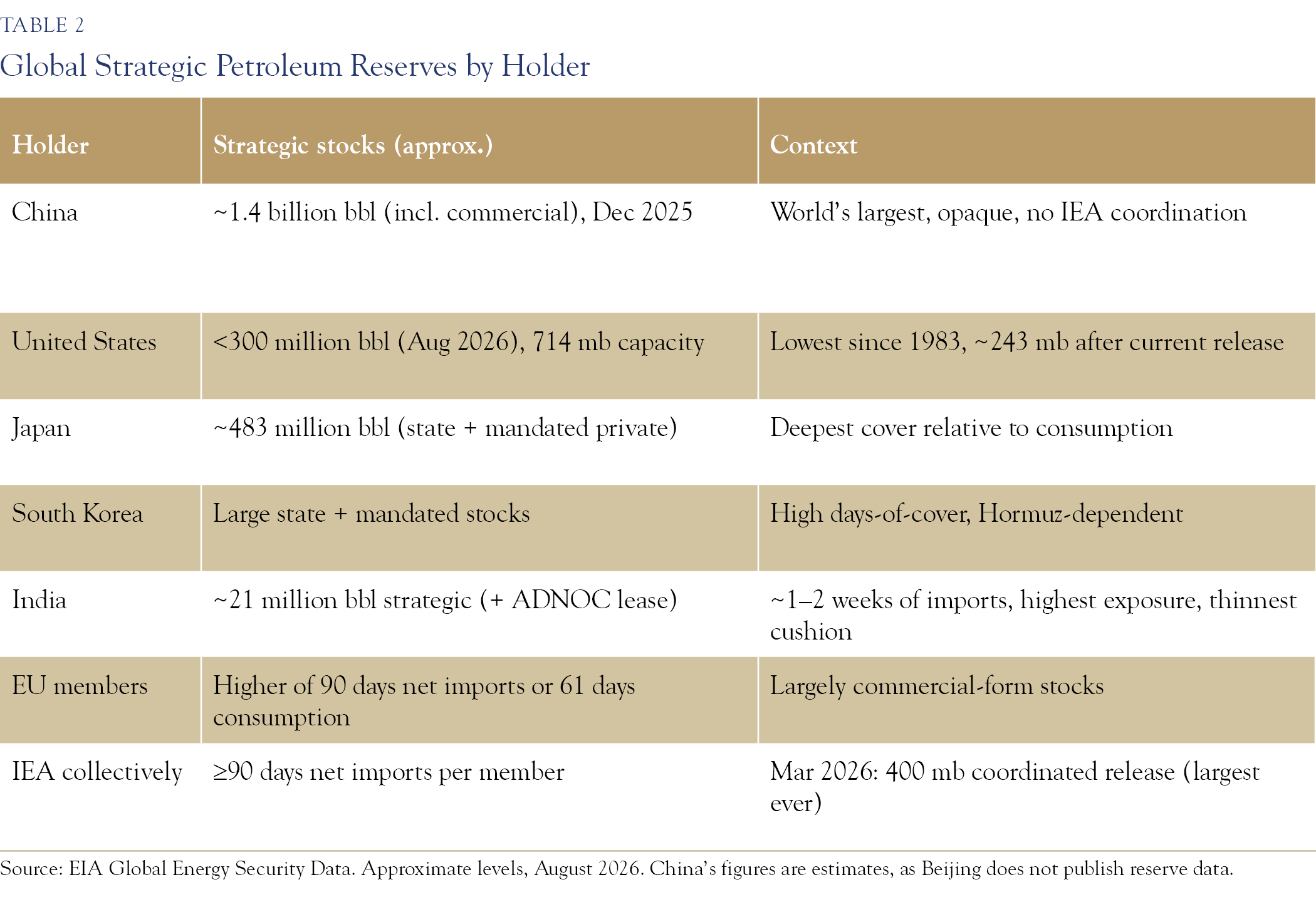
Global Strategic Petroleum Reserves
The United States’ Strategic Petroleum Reserve, salt caverns with a design capacity of 714 million barrels, entered the crisis at roughly 415 million barrels, still depleted from the 180-million-barrel release in 2022. The 172-million-barrel release in March 2026 has driven inventory below 300 million barrels, the lowest since 1983, en route to about 243 million barrels when the release completes. The fine print matters. The design drawdown rate of 4.4 million barrels per day had fallen to about 2.7 million by late 2025, while observed delivery during the current release has been closer to 0.9 million barrels per day, and the GAO found more than a quarter of the inventory unavailable due to construction and cavern outages. The reserve is closer to its operational floor than to its capacity.
China holds the largest emergency stockpile in the world, an estimated 1.4 billion barrels as of December 2025 across government and commercial storage, equal to several months of imports, and reports none of it to any international body. Japan and South Korea keep the deepest reserves relative to consumption among IEA members. Japan’s combined state and mandated private stocks, at roughly 483 million barrels, exceed the pre-crisis U.S. SPR. India, whose Hormuz exposure is among the largest, holds one of the thinnest cushions, about 21 million barrels, one to two weeks of imports. The EU requires the higher of 90 days of net imports or 61 days of consumption, largely in commercial form.
This communication contains the personal opinions, as of the date set forth herein, about the securities, investments and/or economic subjects discussed by Mr. Chaudhri. No part of Mr. Chaudhri’s compensation was, is or will be related to any specific views contained in these materials. This communication is intended for information purposes only and does not recommend or solicit the purchase or sale of specific securities or investment services. Readers should not infer or assume that any securities, sectors or markets described were or will be profitable or are appropriate to meet the objectives, situation or needs of a particular individual or family, as the implementation of any financial strategy should only be made after consultation with your attorney, tax advisor and investment advisor. All material presented is compiled from sources believed to be reliable, but accuracy or completeness cannot be guaranteed.
© Silvercrest Asset Management Group LLC